
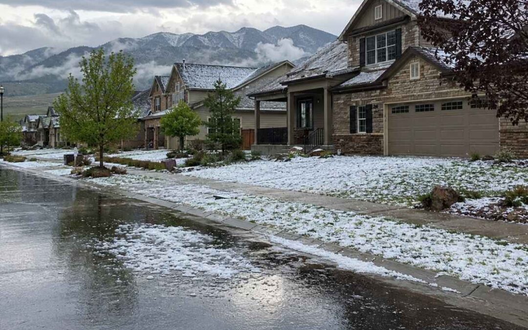
Colorado Front Range hail zones are the geographic corridors along the eastern base of the Rocky Mountains where atmospheric conditions produce the highest concentration of damaging hail in North America. The Storm Prediction Center’s severe weather climatology records seven to nine hail days per year across this corridor. Meteorologists and insurers call it Hail Alley.
The zone stretches from Fort Collins south through Metro Denver and Castle Rock to Colorado Springs, roughly following the I-25 corridor and the adjacent High Plains. Thinner air at 5,000 to 6,500 feet reduces drag on falling hailstones, so identical stones strike Front Range roofs with more kinetic energy than they would at lower elevations.
Castle Rock and the Metro Denver corridor absorb the heaviest share of Front Range hail damage. The NOAA Storm Events Database archives more than 100 hail reports within 10 miles of Castle Rock since 2004. The Insurance Information Institute ranks Colorado consistently among the top three states for hail claim frequency.
Abraham Benson Roofing works across Castle Rock and Metro Denver, where 20 years of Front Range roof inspections after hailstorms reveal the same pattern: granule displacement and mat fracture that standard architectural shingles at elevation cannot absorb.
What Are Colorado Front Range Hail Zones?
Colorado Front Range hail zones are the geographic corridors along the eastern base of the Rocky Mountains, from Fort Collins through Metro Denver and Castle Rock to Colorado Springs, where atmospheric conditions produce the highest concentration of damaging hail events in North America. The Storm Prediction Center’s severe weather climatology classifies this corridor as averaging seven to nine hail days annually, more than nearly any other region in the country. Insurers and meteorologists call it Hail Alley.
The corridor tracks the I-25 urban band from the Wyoming border south to Pueblo and extends east across the adjacent High Plains. Open terrain and minimal tree cover give hailstones an uninterrupted fall path to roofs, vehicles, and crops.
The highest frequency of severe hail, defined as stones 1 inch in diameter or larger, concentrates near the Wyoming-Nebraska-Colorado border according to the Insurance Institute for Business and Home Safety. The populated Front Range cities from Fort Collins to Colorado Springs sit south of that peak frequency zone but catch the most insured damage because roofs, siding, and vehicles concentrate by the hundreds of thousands along the I-25 corridor.
One supercell crossing Metro Denver can damage roofs across dozens of neighborhoods in a single pass.
Hail zone designation is not a single line on a map. Risk shifts by elevation, foothills proximity, and storm track position.
Castle Rock sits at approximately 6,220 feet on the Palmer Divide, the elevated ridge running east-west between Denver and Colorado Springs. Metro Denver sits at 5,280 feet in the direct path of northeast-tracking afternoon storms. A property in Castle Rock faces different exposure than a property in Lakewood or Aurora at 1,000 feet lower elevation.
Why the Front Range Produces More Damaging Hail Than Other U.S. Regions
The Front Range produces more damaging hail than other U.S. regions because three atmospheric conditions converge here: orographic lift from the Rocky Mountain foothills forces air upward to trigger severe thunderstorms, vertical wind shear tilts and sustains the updrafts that grow large hailstones, and high elevation thins the air so hailstones strike with greater kinetic energy than identical stones at lower elevations. No other U.S. region combines all three.
Orographic lift starts the chain. Air masses hit the foothills and ride upward into altitudes where steep lapse rates drop temperatures well below freezing. Gulf of Mexico moisture collides with cold Canadian air over this corridor, fueling supercell thunderstorms. Vertical wind shear along the Rockies’ lee side then tilts the updraft so hailstones cycle through the freezing zone repeatedly, growing larger with each pass.
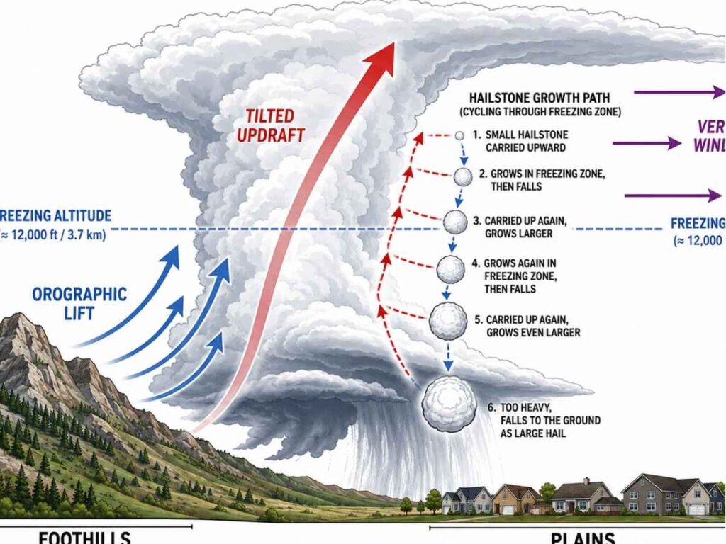
The Palmer Divide between Castle Rock and Colorado Springs adds a secondary lift source. The NWS Denver/Boulder forecast office monitors these conditions daily during hail season because the pattern repeats frequently enough for forecasters to spot hail-capable atmospheres hours before the first cell fires.
Elevation is the factor most homeowners overlook. The IBHS documented that a 1-inch hailstone striking a Denver roof at 5,280 feet carries the same kinetic energy as a 1.2-inch hailstone would in Dallas, because lower air density at altitude reduces aerodynamic drag and increases terminal velocity on impact.
Front Range storms also produce more hailstones per square foot than lower-elevation storms, according to IBHS research. That compound effect means Front Range roofs absorb more total impact energy per storm than roofs in north Texas or the Midwest. Standard architectural shingles rated for lower-elevation hail markets lose granule coverage and develop mat fractures faster under these conditions.
Where Hail Hits Hardest Along the I-25 Corridor
Hail damage along the I-25 corridor concentrates in two distinct zones: Castle Rock and Douglas County, where the NOAA Storm Events Database documents 107 hail events within 10 miles since 2004 with stones reaching baseball size, and the Metro Denver northeast corridor from Lakewood through Aurora and Commerce City, where insurance claim data shows the highest per-neighborhood claim frequency in the state.
Castle Rock and Douglas County Hail Frequency Data
Castle Rock has recorded 107 hail reports within 10 miles of its center since 2004, according to the NOAA Storm Events Database archive on stormersite.com. The largest documented hailstone reached 3.00 inches, hockey-puck size. Zip code 80116 covering Franktown and eastern Douglas County leads the county with 37 damaging hail reports in that period, and zip code 80104 covering central Castle Rock follows with 32.
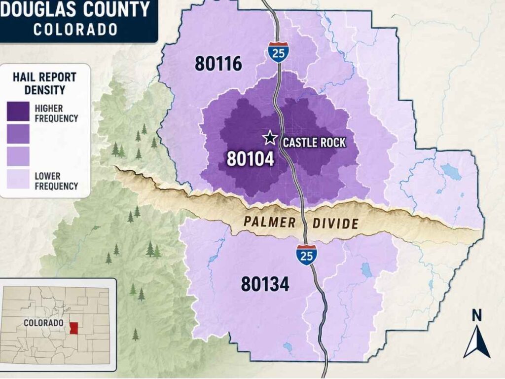
The June 8, 2019 storm produced 2.50-inch baseball-sized hail north of Castle Rock. Corrected NWS reports confirmed multiple impacts in a single afternoon. The most recent significant event as of mid-2026 struck on June 8, 2026, producing 1.50-inch ping-pong-ball-sized hail across zip code 80134. Stormersite.com confirmed five hail reports for Castle Rock through that date in 2026, with the June 8 event producing the largest stones of the year.
Castle Rock’s position at 6,220 feet on the Palmer Divide places it at the convergence point where afternoon storms generated by foothills heating intensify as they cross the ridge. Storms that might produce quarter-sized hail at lower elevations west of the Divide often escalate to golf-ball or larger stones by the time they reach Castle Rock’s eastern slope.
Douglas County is approaching 56% of its development capacity. That growth puts more roofs, vehicles, and insured structures into a corridor already among the most hail-active in the state. Interactive Hail Maps data confirms 35 on-ground spotter-confirmed hail events and 124 Doppler radar-detected hail occurrences near Castle Rock within the past 12 months.
Metro Denver Northeast Storm Corridor
Hail damage in the Denver metro does not distribute evenly. Claims cluster along a northeast-trending corridor from west Lakewood through central Denver and continuing through Aurora and Commerce City. The pattern matches the path afternoon thunderstorms follow as they develop over the foothills, drift east-northeast with prevailing upper-level winds, and intensify over the urban heat island. Sloan’s Lake, Highland, Five Points, Park Hill, and northeast Aurora appear repeatedly in high-claim years.
The May 8, 2017 storm illustrated the Lakewood-to-Commerce-City corridor at full scale: the Rocky Mountain Insurance Information Association documented 100,600 homeowner claims, 167,000 auto claims, and $2.3 billion in total insured losses. Westminster, Thornton, Northglenn, and Brighton extend the corridor north along I-25 into Adams and southern Weld counties. Colorado’s top-three ranking in statewide hail claim frequency falls disproportionately on the Denver metro.
When Does Hail Season Peak on the Colorado Front Range?
Colorado hail season runs from April through September, but 60% to 70% of significant hail damage along the Front Range concentrates in a six-week window from approximately May 15 through June 25, according to NOAA Storm Events Database records. The Colorado State University climate center confirms that severe hail days peak in early to mid-June. June is the single most active month.
Hailstones exceeding 2 inches in diameter, the size threshold that causes structural roof damage on standard architectural shingles, are historically most likely from late May through the last week of June. The 2024 season illustrated this concentration: the May 2024 Denver hailstorm alone generated approximately $2 billion in insured losses, and the most damaging events across Denver, Aurora, and Castle Rock fell between May 20 and June 28. Some sources extend the broader risk window through mid-July, but the NOAA data shows the sharpest damage concentration ending by late June.
Most storms fire between 1 PM and 7 PM. The classic Colorado pattern of clear mornings building to afternoon thunderstorms drives this timing: storms develop over the higher terrain west of the foothills around midday, organize as they move east, and intensify over the plains by mid-afternoon.
The Castle Rock-through-southeastern-Denver corridor tends to see its most intense activity in a tighter four-week period from late May through mid-June. The monsoon moisture shift in late June changes storm character from dry-based hail producers to rain-dominant systems. Hail season tapers sharply after the last week of June even though thunderstorm activity continues through August, because the moisture source that feeds the storms shifts from Gulf of Mexico instability to subtropical monsoon flow that favors heavy rain over large hail.
How Does Front Range Elevation Change Hail Impact Force?
A 1-inch hailstone striking a Denver roof at 5,280 feet carries the same kinetic energy as a 1.2-inch hailstone would in Dallas, because lower air density at altitude reduces aerodynamic drag and increases terminal velocity on impact. The IBHS confirmed this equivalency and documented that Front Range storms produce more hailstones per square foot than storms in lower-elevation hail regions.
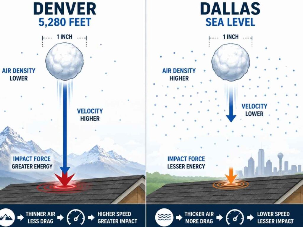
The energy gap widens with altitude. Colorado Springs sits at 6,035 feet and Castle Rock at 6,220 feet, both higher than Denver’s 5,280-foot baseline. At those elevations, a 1-inch stone arrives with even greater kinetic energy than the Denver-to-Dallas comparison suggests, because each additional 500 feet of elevation thins the air further and reduces drag by a measurable increment. Standard architectural shingles engineered for lower-elevation hail markets absorb more energy per impact on Front Range roofs even when the hailstone is the same diameter.
The UL 2218 impact resistance test, the standard that defines Class 4 as the highest shingle rating, drops a 2-inch steel ball from 20 feet to simulate hail impact. The test calibrates to sea-level terminal velocity. At Front Range elevation, actual hailstones of the same diameter arrive with higher kinetic energy than the test simulates.
The altitude factor does not make Class 4 shingles inadequate at elevation. The safety margin built into the Class 4 rating is narrower on a Castle Rock roof than on a roof in Dallas or St. Louis. Choosing a standard non-impact-rated shingle at Front Range elevation accepts significantly more risk than the same choice would represent in a lower-elevation hail zone.
How to Check Your Property’s Hail History on the Front Range
Property owners can check their Front Range hail history through four publicly accessible sources and one insurance-side record that most homeowners do not know they can request. Each source captures a different layer of hail data, from NWS-confirmed storm reports to Doppler radar signatures to insurance claim records filed at a specific address.
- NOAA Storm Events Database. Archives all NWS-confirmed severe weather reports by county and date, including hailstone size, location, and source type (trained spotter or law enforcement).
- Stormersite.com. Aggregates NOAA storm report data into searchable city-level hail archives with hailstone size, date, and distance from city center for faster zip-code lookups.
- Interactive Hail Maps. Overlays Doppler radar hail detection data at the address level, showing both spotter-confirmed ground reports and radar-detected signatures not confirmed on the ground.
- mPING and CoCoRaHS. Two citizen science networks collecting on-the-ground hail reports from trained volunteers across the Front Range, filling gaps where no NWS spotter was present.
The distinction between spotter-confirmed hail and radar-detected hail matters for insurance documentation. A spotter report carries more weight with adjusters because a trained observer measured the stone on the ground. Radar detection confirms hail was present in the atmosphere above a location but does not confirm what size stone reached the surface. Property owners cross-referencing all four sources build a more complete exposure picture than any single tool provides. Stormersite is the fastest starting point.
Insurance carriers maintain their own property-specific hail history through the CLUE database, the Comprehensive Loss Underwriting Exchange operated by LexisNexis. A CLUE report shows every hail claim filed at a specific address within the past seven years, regardless of which insurer covered the loss. Property owners can request their own CLUE report at no cost.
A property with multiple prior hail claims may face higher premiums or reduced coverage options at renewal. A property with zero claims in a high-frequency zone like Castle Rock or the Metro Denver corridor raises a different question: the roof has either avoided significant strikes or has undocumented damage that a professional inspection would identify.
How Do Colorado Hail Zones Affect Homeowner Insurance Rates?
Colorado homeowner insurance rates are directly tied to hail zone geography. The Colorado Division of Insurance has identified hail damage as the number one cost driver of homeowner insurance rates in the state, and carriers writing policies along the I-25 corridor from Castle Rock through Denver tier their wind and hail premiums by geographic risk zone. Higher claim frequency means higher premiums.
Properties in zip codes with more documented hail events pay proportionally more for wind and hail coverage. Carriers like State Farm, USAA, Farmers, and Allstate offer larger Class 4 premium discounts in the highest-frequency zones because the actuarial benefit of impact-resistant roofing is greatest where claims are most concentrated. Colorado homeowners gained a statutory basis for this discount when the legislature passed CRS 10-4-110.8, which requires insurers to factor impact-resistant roofing materials into their premium rate structures.
In June 2026, Governor Polis signed SB26-155, creating the Strengthen Colorado Homes Enterprise within the Division of Insurance. Starting no sooner than January 2027, insurers must demonstrate in their rate filings that savings from resilient roof installations are reaching policyholders, shifting the Class 4 discount from voluntary to enforceable. The discount is not automatic. Homeowners need three elements to activate it: qualifying Class 4 materials on the roof, a closed building permit, and the manufacturer’s UL 2218 certification letter submitted to their carrier.
A typical Metro Denver homeowner carrying $400,000 in dwelling coverage under a replacement cost value policy on a $2,400 annual premium could see the dwelling-allocated portion discounted by 15% to 30%, producing $360 to $720 in annual savings. Actual cash value policies calculate the discount differently because the payout depreciates with roof age, making the premium reduction smaller on older roofs. Carrier-to-carrier variation means the specific discount depends on the policy and the insurer writing it.
How to Choose Roof Protection Based on Your Front Range Hail Zone
Three zone-specific variables determine the right roof protection level for a property along the Castle Rock-to-Denver I-25 corridor. Each variable shifts the cost-benefit math on material selection differently.
- Hail frequency at the property’s location. A property in zip code 80116 with 37 documented hail reports since 2004 faces fundamentally different exposure than a western foothills property with single-digit reports.
- Elevation kinetic energy factor. At Castle Rock’s 6,220 feet, hailstones arrive with more impact energy than at Denver’s 5,280 feet, which already exceeds any lower-elevation market.
- Carrier zone tiering on the Class 4 discount. Some insurers offer larger CRS 10-4-110.8 discounts in the highest-frequency zones, shortening the payback on the $1,000 to $2,000 Class 4 upgrade for Castle Rock and corridor properties.
Higher frequency shortens the interval between damaging strikes, and higher elevation transfers more energy per strike into the roofing material. Properties where all three variables score high are where Class 4 materials like SBS-modified asphalt shingles or stone-coated steel deliver the strongest combined return: longer service life under repeated impact, fewer claim cycles, and faster premium savings recapture. Properties where one or two variables are low still benefit from Class 4, but the payback timeline extends and the decision depends more on roof age and remaining service life.
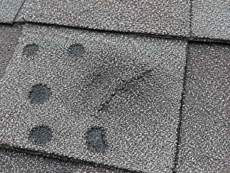
A pre-season inspection scheduled before mid-May is the highest-return action in a high-frequency hail zone. The inspection documents current roof condition, identifies pre-existing wear that a post-storm adjuster would separate from new storm damage, and establishes a dated baseline for any future insurance claim.
Roof age matters most in this decision. A roof older than 10 years in the Castle Rock or Metro Denver corridor has absorbed multiple hail seasons, and granule loss compounds with each event whether or not a claim was filed. The mid-May peak window sets the practical deadline for completing a pre-storm baseline inspection.

Recent Comments